Drone Surveys + Aerial Inspections
Elevating INsight: How Drone Surveys Deliver Safer, Smarter Property Assessments.
At INform Surveying, we’re constantly exploring innovative ways to enhance the quality, safety, and efficiency of our building inspections. One of the key tools revolutionising our surveying capabilities is drone technology. Drone surveys allow us to carry out detailed inspections of hard-to-reach areas safely and efficiently, while delivering high-resolution data that supports smarter decisions and better outcomes for our clients.
In this blog, we’ll explore how drone surveys work, when and why they’re used, and what value they bring to commercial property owners, investors, and managers. With a focus on practical application and informed insight, INform Surveying continues to push forward with smart surveying solutions that put our clients first.
- Complementary services:
- + Building survey
- + Schedules of condition
- + Dilapidations
What Makes a Great Drone Survey:
Key Considerations
01 Planning and Permissions:
Before any flight, we undertake detailed planning to ensure safety and legal compliance. This includes assessing airspace restrictions, preparing risk assessments, and ensuring our pilots are certified and insured in line with Civil Aviation Authority (CAA) regulations.
02 High-Resolution Data Collection
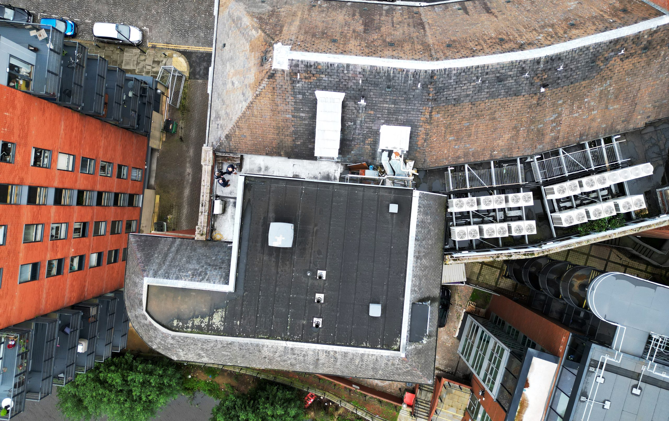
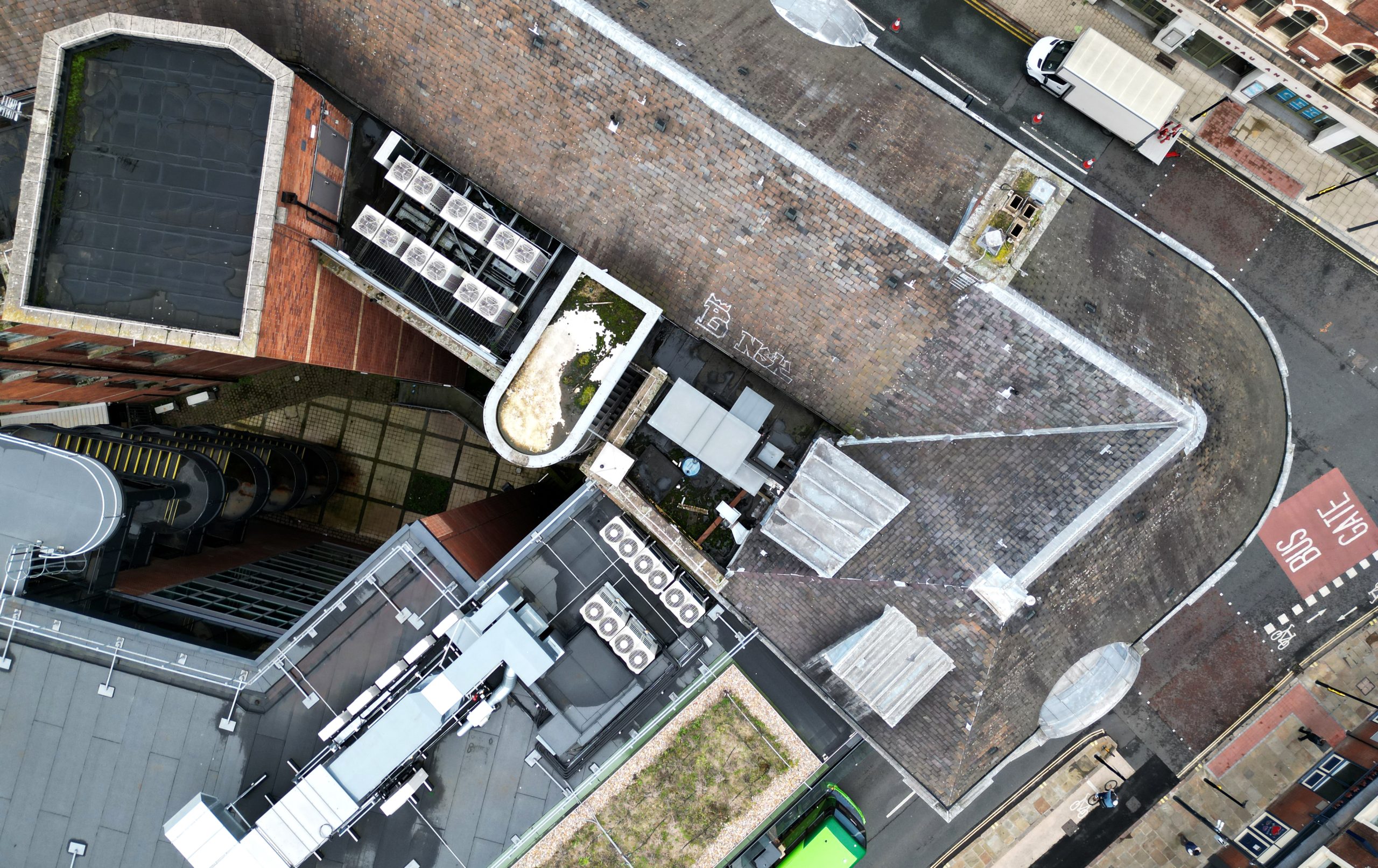
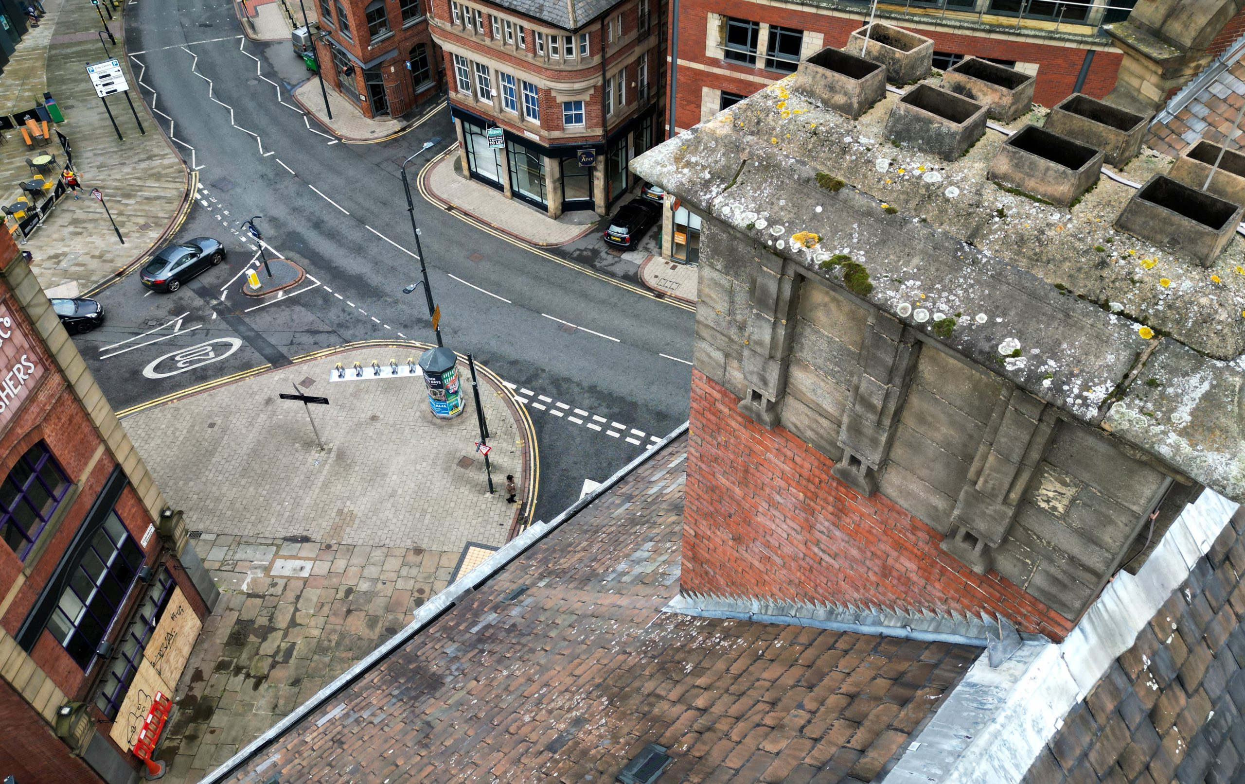
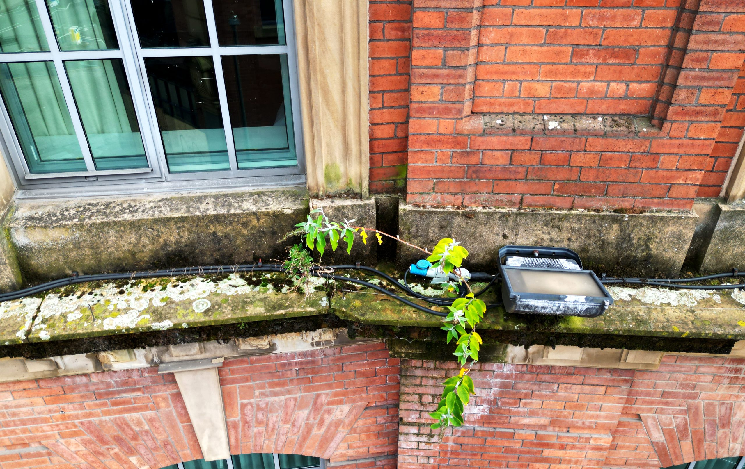
Our drones are equipped with 4K+ resolution cameras capable of capturing sharp, detailed imagery and video. This allows us to identify issues such as cracked parapets, missing roof tiles, corrosion, plant growth, and more with greater clarity than can typically be achieved through standard ground-based observation.
03 Integration with Survey Reports:
Drone footage is seamlessly integrated into our survey reports, enhancing traditional inspection findings. Clients receive annotated images, aerial overviews, and video clips that provide a clear, visual understanding of the property’s condition. This makes it easier to see exactly where and what the issues are, which is especially useful for roof areas that may otherwise remain unseen.
04 Speed and Efficiency:
Drone surveys can typically be completed in a fraction of the time required for manual access methods. This allows us to deliver findings quickly, which is ideal for time-sensitive acquisitions or reactive maintenance requirements.
05 Supporting Technical Diagnosis:
While drone imagery is excellent for visual inspection, it also acts as a complementary tool to hands-on surveys. In many cases, drone imagery helps pinpoint areas that require close-up manual examination or confirms issues noted elsewhere. We focus on using the right method to achieve the best result.
WHY DRONE SURVEY’S MATTER
Traditional access methods like scaffolding or cherry pickers can be time-consuming, costly, and sometimes impractical, especially on large or complex commercial buildings. Drone surveys offer a safe, efficient, and cost-effective alternative that enables us to:
– Access difficult or dangerous locations (e.g., tall roofs, confined areas, fragile surfaces)
– Identify defects and deterioration early through high-definition imagery
– Minimise disruption to business operations during the survey process
– Improve health and safety by reducing the need for working at height
– We use advanced mission planning software to design automated flight paths, ensuring comprehensive and methodical coverage of larger areas and sites
– Our fleet comprises three drones of varying sizes, allowing us to operate within CAA regulations in built up areas by deploying a smaller aircraft where larger drones may not be permitted
Drone technology has become a vital part of our toolkit, particularly for roof inspections, façade assessments, and high-level maintenance planning.

For further information and advice on NEIGHBOURLY MATTERS please contact:


Our founders are always available for advice or support—feel free to reach out directly.
To learn more about our journey and values, visit our About Us page. Together, we’ve built a consultancy dedicated to placing clients first, delivering not just solutions, but clarity, precision, and long-term success.
CASE STUDY: HOTEL CHAIN : UK WIDE
Introduction and Client Background
A longstanding client with a portfolio of large industrial sites across the Midlands required an urgent condition survey of several warehouse roofs. Many of these buildings had limited access and no existing safe means of roof inspection.
Objectives of the survey
The main objective was to assess the general condition of the roofing systems, particularly for signs of water ingress, membrane damage, and debris accumulation. The client needed to determine whether urgent repairs were necessary before winter and to inform their long-term maintenance budgeting.
Survey Methodology
After securing the necessary permissions and carrying out a risk assessment, we conducted a series of drone flights over the affected sites. High-resolution images and videos were captured from multiple angles, providing a full view of roof slopes, parapets, drainage points, and service penetrations.
All imagery was processed, annotated, and combined with on-ground observations to build a complete picture of the roof conditions. In some locations, we used thermal imaging to assess insulation performance and identify potential moisture build-up.
Findings and Solutions
The survey revealed several key issues:
-
Ponding water on multiple flat roof sections
-
Blocked drainage outlets and debris build-up
-
Early signs of membrane blistering
-
Dislodged coping stones on perimeter parapets
The drone imagery enabled the client to clearly see the location and scale of each issue. From this, we provided a priority-based maintenance plan with estimated costs, helping the client take proactive steps before problems escalated.

Outcome and Client Feedback
The client was impressed with both the speed and clarity of the findings. The visual documentation provided made internal approvals for remedial works faster and easier. Most importantly, the drone survey removed the need for temporary roof access or disruption to Hotel guests, saving time and cost.
Conclusion
Drone surveys are transforming how we inspect and manage commercial buildings. At INform Surveying, we use drones not as a replacement for traditional surveying methods, but as a powerful complement that enhances access, improves safety, and delivers visual insight. This helps our clients act with clarity and confidence.
Whether you’re managing a complex portfolio or require a single-site assessment, our drone surveys bring a new level of precision and perspective to property inspections.
Interested in exploring how drone technology can support your property strategy?
Contact Inform Surveying today to find out how we can elevate your next building inspection.
CONTACT US
If you’d like to arrange a meeting or learn more about what we do, please email us or give us a call.
'Inform Surveying is committed to achieving net zero carbon emissions across our operations and value chain, covering Scopes 1, 2, and 3 emissions in line with the Greenhouse Gas Protocol. This includes direct emissions from company-owned vehicles and on-site fuel use (Scope 1), indirect emissions from purchased energy such as electricity and heating (Scope 2), and other indirect emissions across our value chain, including business travel, procurement, and waste (Scope 3).
We have set a target to reach net zero by 2050, with interim milestones to reduce carbon intensity across all scopes. Our approach includes implementing energy efficiency measures, transitioning to renewable energy, reducing business travel, and engaging suppliers and partners to adopt sustainable practices.
While Inform Surveying does not yet have targets formally validated by the Science Based Targets initiative (SBTi), we are committed to aligning our strategy with science-based principles and plan to seek SBTi validation as our carbon reduction program develops.'
CONTACT INFORMATION
Our Office
102-103 Hague, Park Hill,
South Street, Sheffield S2 5AS
What 3 words: placed.backed.agenda
Open Office Hours
Mon-Fri : 9:00am - 5:30pm
Get in Touch
+44(0)114 321 9919
